The Curse of Oak Island- Season 7, Episode 5: Tunnel Visions
The following is a plot summary and analysis of Season 7, Episode 5 of the History Channel’s TV series The Curse of Oak Island.
[SPOILER ALERT!!!]
Plot Summary
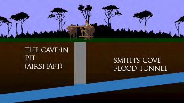
This episode begins just north of the Cave-In Pit, at one of the anomalies discovered during the ground penetrating radar scan conducted in Season 7, Episode 2. We learn through Terry Matheson’s conversation with Doug Crowell that Choice Drilling is in the process of sinking a hole in this location. While core samples are retrieved from the hole, the narrator reminds us that the Oak Island Treasure Company, back in 1897, discovered the junction of the Smith’s Cove flood tunnel and the Money Pit at a depth of 111 feet.
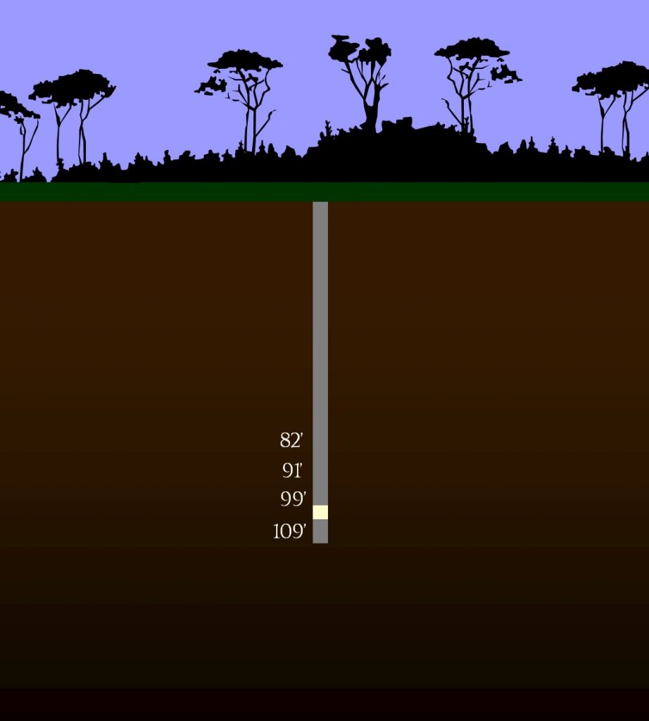
Matheson, Crowell, Jack Begley, and Paul Troutman examine a core sample from Cave-In Pit 2, taken from a depth of 99-109 feet. The sample contains four feet of sand which stands out from the surrounding till, which the treasure hunters- including an especially enthusiastic Doug Crowell- speculate might be remnants of the Smith’s Cove flood tunnel. The four men call over Rick and Marty Lagina, Craig Tester, and Dave Blankenship and inform them of the potential discovery. Rick observes that the core sample contains no wood, unlike the sample discovered on Smith’s Cove’s Upper Beach in the previous episode. Marty responds by remarking that, if he had been tasked with constructing a flood tunnel that was to last a thousand years, he might have packed it with sand rather than support it with cribbing. The treasure hunters agree to sink another hole west of Cave-In Pit 2, on a line connecting the U-shaped structure with the Money Pit area, in order to determine whether or not the sand continues in that direction.
Later, Gary Drayton, Jack Begley, and Peter Fornetti go metal detecting on Oak Island’s Lot 27, first owned by Daniel McGinnis. After passing over some unknown metallic object which Drayton dismisses as “modern junk”, the metal detecting expert discovers a rusted iron chisel. When prompted by Jack Begley, Drayton speculates that the object might be as old as the swage blocks which he discovered on Lot 21 in Season 7, Episode 2, and that it might have been used for tunneling through rock.
That afternoon, the Oak Island crew returns to the Cave-In Pit area, where a hole 5 feet west of the so-called “Cave-In Pit 2” is being drilled. A core sample taken from a depth of 99-109 feet contains some sand mixed with clay, but nothing resembling the four feet of pure sand found in “Cave-In Pit 2”. In light of this setback, the crew decides to abandon the drilling operation and later conduct a seismic scan in the area.
The next day, members of the Oak Island team meet with Alex Gauthier and Scott Graychick of Eagle Canada. During their subsequent conversation, we learn that Eagle Canada has been tasked with conducting a massive seismic survey of the entire eastern end of Oak Island.
That afternoon, Craig Tester, Alex Lagina, and Laird Niven meet with GPR experts Steve Watson and Don Johnston at the foundations of the old McGinnis family cabin. We learn that the Oak Island team has decided to conduct an archaeological investigation of the foundations, and that the first step in this process is to perform a Ground Penetrating Radar scan of the area. “We’re going to have you guys come in and do your work,” Niven explains to the GPR experts, “and identify anomalies that could be significant, and based on that data, we’re going to write a new permit application for some subsurface testing- some excavation.”
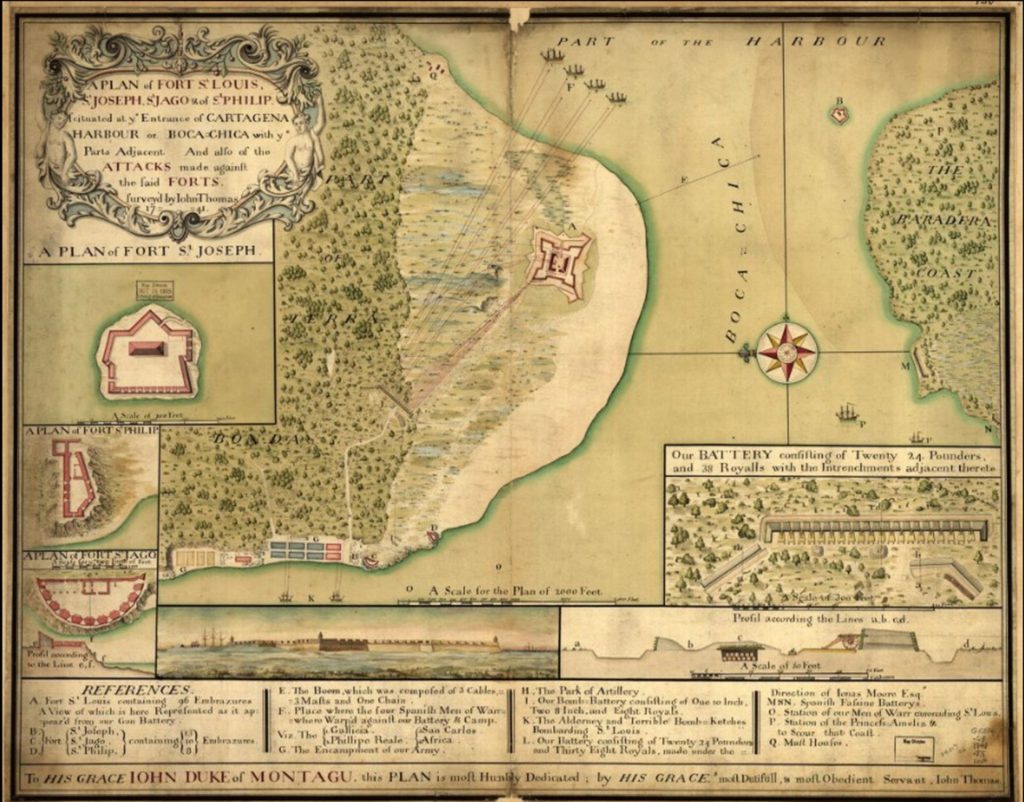
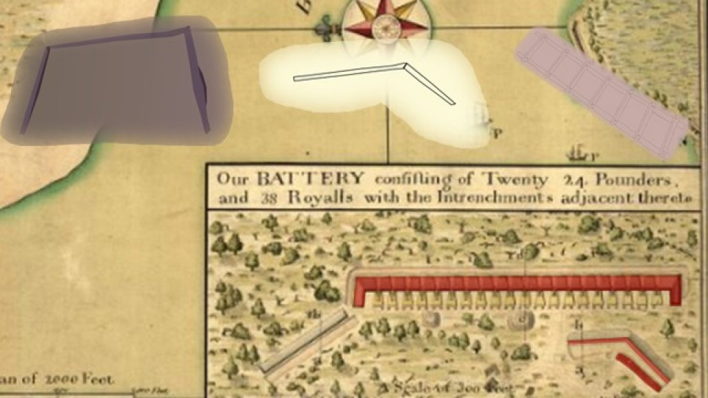
Later, the Fellowship of the Dig meets in the War Room with naval historian Chipp Reid, who has come to share his theory regarding the nature of the structures discovered at Smith’s Cove. Reid shows the boys a diagram depicting a ‘water battery’, which he describes as “an artillery position that’s constructed as close to the shoreline as possible” (although it is not mentioned in this episode, this diagram is from a map of Cartagena, Colombia, drawn by English engineer John Thomas the Elder in 1741). He claims that the particular water battery depicted in the diagram was common from roughly 1600-1850. He then points out structures on the diagram which closely resemble the U-shaped structure, the L-shaped structure, and the slipway, respectively, implying that the mysterious workings at Smith’s Cove constitute the remains of a water battery. Reid then suggests that, if the structures discovered at Smith’s Cove indeed comprise a water battery, and if the structures indeed date to the mid-18th Century (as the dendrochronological dating carried out in Season 6, Episode 21 indicate), then the battery was probably constructed by members of the French military. The narrator proceeds to lecture us on the history of the Fortress of Louisbourg, an enormous French fortress constructed on Cape Breton Island from 1713-1740. Reid concludes his presentation by theorizing that the French military used Oak Island as a water battery in the early 1700s, and that they hid the treasury of Louisbourg on the island prior to the First Siege of Louisbourg in 1745.
Following Reid’s presentation, Craig Tester, Alex Lagina, and Laird Niven meet at the foundations of the McGinnis family cabin. There, Steve Watson and Don Johnston, who have already carried out their GPR scan of the foundations and surrounding area, point out some of the anomalies they came across. The strongest of these is a four-foot-wide anomaly located four feet below the surface. The treasure hunters agree that they ought to excavate these anomalies, for which they will need to acquire a permit from the provincial government.
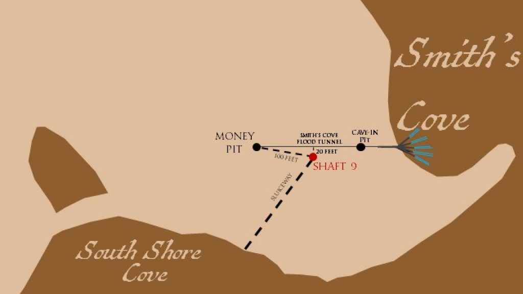
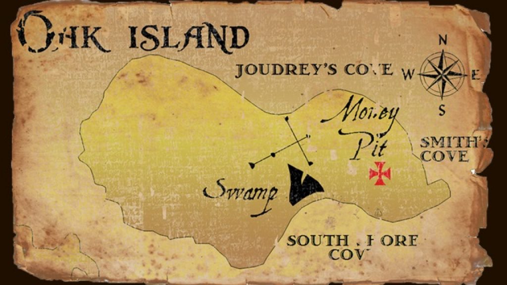
Later, the Lagina brothers and Doug Crowell drive to Oak Island’s Southern Shore. During the drive, Crowell explains that, according to Dan Henskee, Triton Alliance went through the papers of former Oak Island treasure hunter Mel Chappell and learned an interesting piece of Oak Island history. Back in 1863, the Oak Island Association dug a 120-foot deep shaft, called ‘Shaft 9’, about 100 feet southeast of the Money Pit. In order to prevent this tunnel from flooding, they constructed a sluiceway which directed any water which might collect in the tunnel towards the South Shore Cove. That accomplished, the Association built another 108-foot-deep tunnel from Shaft 9 towards the Money Pit. Unfortunately, the Oak Island Association went under before the workers were able to complete this tunnel. Doug Crowell hopes that, if the Fellowship of the Dig manages to locate the sluiceway beneath the South Shore Cove, they may be able to trace it back to Shaft 9 and the tunnel connected to it, which extends in the direction of the Money Pit.
Doug Crowell directs the Lagina brothers to the site at which the mouth of the sluiceway is believed to lie, whereupon Marty Lagina begins excavating the area with a backhoe. At first, Marty unearths nothing besides a rusted length of pipe. When he reaches a depth of about ten feet, water begins flooding into the hole. The younger Lagina brother proceeds to dig in the direction of the water source and discovers a wooden tunnel which appears to be the mouth of the sluiceway. The treasure hunters watch with pleasure and surprise as water gushes from the opening, marveling that sluiceway still works after 156 years. They agree that they ought to follow the sluiceway to Shaft 9, and hopefully to the Money Pit beyond.
Analysis
The Composition of the Smith’s Cove Flood Tunnel
In this episode, the Oak Island team drilled into one of the anomalies near the Cave-In Pit discovered during a GPR scan carried out in Season 7, Episode 2. Although nothing of interest appeared at the depth of interested indicated by the GPR scan (either 82 feet or 91 feet, depending on which anomaly was investigated), a core sample taken from 99-109 feet contained four feet of pure sand. Some members of the crew believed that this sand might be remains of the Smith’s Cove flood tunnel. Indeed, Marty Lagina, who is an engineer by profession, remarked that if he had been tasked with constructing a flood tunnel that was to last a thousand years, he might have packed it with sand rather than support it with cribbing.
The notion that the Smith’s Cove flood tunnel might have been packed with sand is a new idea that has not previously been suggested on the show. This notion appears to conflict with the generally accepted purpose of the coconut-eelgrass filter discovered at Smith’s Cove by the Truro Company in 1850, namely that the filter was designed to prevent the Smith’s Cove flood tunnel from becoming clogged with sand and debris. It also runs contrary to the idea that the tunnel is supported by wooden cribbing, as suggested by members of the Oak Island team following the discovery of hand-cut beams in OITC-6 the previous episode. Perhaps most importantly, however, it conflicts with a discovery made by the Oak Island Treasure Company, which was mentioned in this episode. In the spring of 1897, the men of the Oak Island Treasure Company cleared out the Money Pit to a depth of 111 feet. There, they got a good look at the entrance of the Smith’s Cove flood tunnel before floodwater overcame their pumps. According to the workers, the flood tunnel was 4 feet high, 2.5 feet wide, and constructed from rock.
Whatever the case, a second hole sunk five feet west of the sand anomaly, on a line connecting the U-shaped structure with the Money Pit area, yielded nothing of interest, prompting the crew to abandon their drilling operation.
Upcoming Seismic Survey of the Eastern Drumlin
In this episode, we learned that the seismic exploration company Eagle Canada has been tasked with conducting an enormous seismic scan of the entire eastern end of Oak Island. This operation will be the third seismic scan conducted on Oak Island. Throughout Season 6, Eagle Canada carried out seismic scans in the Money Pit area, the Swamp, and a place northwest of the swamp dubbed the ‘Mega Bin’ area. Although these scans revealed several tantalizing anomalies, further investigation of these anomalies failed to yield anything of interest.
Chipp Reid’s Theory
In this episode, naval historian Chipp Reid presented his own theory regarding the nature of the mysterious workings discovered at Smith’s Cove the previous season. Using a map of Cartagena, Colombia, drawn by English engineer John Thomas the Elder in 1741, he demonstrated that some of the structures discovered at Smith’s Cove- including the U-Shaped structure, the L-shaped structure, and the slipway- bear remarkable resemblance to components of a ‘water battery’, or a beachside artillery station. He went on to suggest that the battery was constructed by members of the French military, who had a major presence in Nova Scotia throughout much of the 17th and 18th Centuries. He also suggested that the battery was constructed in the early 1700s, and expressed partiality towards the theory that the Oak Island treasure consists of the treasury of the Fortress of Louisbourg, buried by members of the French military prior to the First Siege of Louisbourg in 1745.
One major problem with Reid’s theory, of which the naval historian is doubtless aware, is the dendrochronological dating of the various Smith’s Cove structures carried out in Season 6, Episode 21. Specifically, wood from the slipway was dated to 1771, and wood from the U-shaped structure was dated to 1769. If the dendrochronological dating is accurate, then it is unlikely that the French had a hand in the structures’ construction. The French lost peninsular Nova Scotia to the British during Queen Anne’s War (1702-1713), the North American theatre of the War of Spanish Succession, only retaining the large island that lies north of the peninsula, known today as Cape Breton Island. Although the French made several attempts to retake peninsular Nova Scotia, including the disastrous Duc d’Anville Expedition of 1746, they never succeeded in their endeavors. The French lost their Nova Scotian holdings to the British for good in 1758, following the second Siege of Louisbourg. By 1769, when the trees of which the U-shaped structure is comprised were felled, all of Nova Scotia was firmly in British hands.
Shaft 9 and the Sluiceway
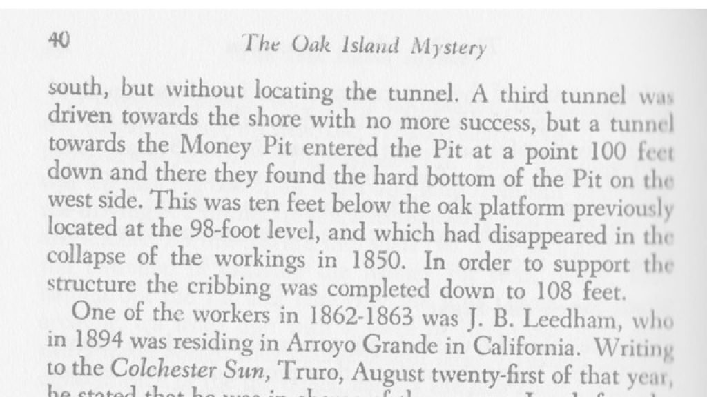
Near the end of this episode, we learn about a lost Oak Island landmark discovered years prior by Dan Henskee and members of Triton Alliance, who made the discovery while looking through the papers of former Oak Island treasure hunter Mel Chappell. Back in 1863, the Oak Island Association dug a 120-foot deep shaft, called ‘Shaft 9’, about 100 feet southeast of the Money Pit and 20 feet south of the Smith’s Cove flood tunnel. In order to prevent this tunnel from flooding, they constructed a sluiceway which directed any water which might collect in the tunnel towards the South Shore Cove (it must be mentioned that, in his 1958 book The Oak Island Mystery, Oak Island lawyer R.V. Harris stated that this tunnel connecting Shaft 9 with the South Shore Cove was intended to intercept the South Shore Cove flood tunnel). That accomplished, the Association built another 108-foot-deep tunnel from Shaft 9 towards the Money Pit. Although the narrator informed us in this episode that the workers were unable to complete this tunnel, R.V. Harris, in his book, stated that this tunnel “entered the [Money] Pit at a point 100 feet down and there they found the hard bottom of the Pit on the west side.”
Whatever the case, Doug Crowell, in this episode, directed Rick and Marty Lagina to a place on the South Shore Cove where the mouth of the Shaft 9 sluiceway was believed to be located. Marty Lagina excavated this area with a backhoe and unearthed a wooden tunnel from which water gushed forth. The crewmembers then agreed that they ought to follow this tunnel to Shaft 9, and to the Money Pit beyond.
Thanks for Reading
Thanks for reading! If you enjoyed this article and would like to help support this website, please check out The Oak Island Encyclopedia.


Leave a Reply